Unless you've been hiding under a rock for the past week or so, Ireland is about to be hit with hurricane-strength winds tomorrow morning as Ophelia reaches the south-west coast of Ireland sometime around 5AM on Monday.
The hurricane, which is a Category 3, is extremely rare as it is the strongest ever hurricane recorded so far east of the Atlantic. According to the most up-to-date data as of writing, Cork, Waterford, South Tipperary and Kilkenny are all in the firing line and expected to face the brunt of the damage.
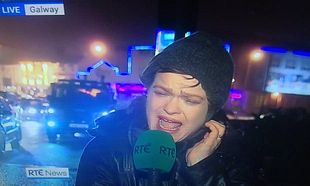
So, what are we doing about it? Aside from the National Emergency Coordination Group meeting today to discuss options, pretty much everyone's making the same joke about Teresa Mannion.
Hi @TeresaMannion - get your coat and hat, you're up! https://t.co/XwHjSiUoEU
— Bernice Harrison (@BerniceHarrison) October 15, 2017
Has someone made sure Teresa Mannion is fully charged? #Ophelia ðŸ'¨â˜”ï¸?🌊⛈
— baz brock (@Bazzyb85) October 15, 2017
Pray for @TeresaMannionhttps://t.co/eV6iWIJyCm
— Darren O'Connor (@Darren_O_Connor) October 14, 2017
Kinda buzzed for this hurricane to hit Ireland purely for the hope that Teresa Mannion will have another iconic report to make
— Sharon (@SharonGranahan) October 13, 2017
Met Éireann has issued a red wind warning for the areas affected by Ophelia and a general orange alert for the entire country, predicting "mean wind speeds in excess of 80 km/h and gusts in excess of 130km/h", as well as the possibility of "structural damage and disruption, with dangerous marine conditions due to high seas and potential flooding."
Via Twitter