This is legit terrifying.
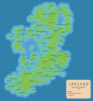
This map projects what Ireland would look like in the year 2100 if the sea-levels rose 70 metres - essentially, a worst-case scenario.
The creators of the map explained it further. "A mate and I made a worst case (70m rise) scenario sea-level rise map of Ireland for the year 2100. We imagined an Ireland after planned inland urban-sprawl as the sea-level will be relatively slow, with designated safe zones that government encouraged investment in."
"We also imagined that most of Dublin’s wealth moved to Bray and Greystones forming the twin city of Braystones (which is slightly more inland than modern Bray and Greystones) while most of Dublin’s people moved to either Tallaght or Maynooth."
Of course they did. Maynooth is the centre of civilised society in Ireland. How dare anyone suggest that the jewel of North Kildare could be lost to some kind of freak apocalypse.
They went on, "Cork/Ennis sprawled inland but most of it was lost, Derry completely relocated as the walled city was submerged and Galway, Limerick and Waterford are all lost for the ages."
So you're saying there's no more Cork? YUSSS.
Here's the map. We've got 85 years to stock up on tinned food and find a Kevin Costner-lookalike to survive the coming apocalypse.
Click the map for a larger image.